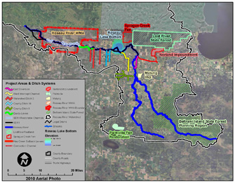
The Roseau River Watershed District (RRWD), part of the Red River Basin, is located in Northwestern Minnesota. It is bordered by Canada to the north, the Warroad and Rapid River Basins to the east, the Red Lake River Basin to the south, and the Two Rivers Basin to the west.
The RRWD has authority, granted by the State of Minnesota, to comprehensively manage the water resources of the district. The Board of Managers, along with the Citizen's Advisory Committee, Technical Advisory Committee, and local landowners work to identify problems and offer solutions to improve water management in the Roseau River Basin.
Drainage Overview
- Total land area: 2,057 square miles in the United States and Canada
- Roseau River outlets to the Red River of the North 9 miles past the Canadian Border
- Lands drained by the Roseau River Watershed: 52% in the United States; 58% in Manitoba, Canada
- The RRWD is entirely within the bed of glacial Lake Agassiz
- Topography is relatively level aside from the linear beach ridges through the basin
- RRWD covers approximately 1,147 square miles (734,800 acres)
- Roseau County: 645,900 acres (88%)
- Lake of the Woods County: 14,700 acres (5%)
- Beltrami County: 36,700 acres (4%)
- Kittson County: 14,700 acres (2%)
- Marshall County: 6,500 acres (1%)
- Upper portion of the RRWD includes the headwaters and tributaries
- Length of the RRWD is approximately 110 miles with a maximum width of 30 miles